|
|
|
||||
|
||
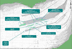
| Here, we provide maps that will help you understand
the exact location and extent of the approved and proposed dredging licence
areas in the East Channel Region. In order to put the ECR operations into
context, you can also view a map showing the full extent of marine aggregate
dredging around the UK coastline. |
|||||||||||||||
|
|
||||||||||||||
|
|
||